Close Menu
    Facebook X (Twitter) Instagram
    Facebook Instagram
    Zoom Japon
    S'identifier
    S'abonner
    0 Shopping Cart
    • À la Une
    • Magazine
      • Abonnement
      • Archives PDF
      • Distribution
    • Dossiers
    • Actu
    • Culture
    • Gourmand
    • Voyage
    • Petites annonces
    • Boutique
    • Japonais
    Zoom Japon
    0 Shopping Cart
    Accueil » Actu » Le Mont Fuji
    Actu

    Le Mont Fuji

    Par Eric Rechsteiner01/04/2013
    Facebook Email

    Parution dans le n°29 (avril 2013)

    "La dernière éruption du mont Fuji date de 1707 mais trois départements du Japon Yamanashi, Shizuoka et Kanagawa viennent - on ne sait jamais - de mettre en place un plan d'évacuation en cas de coulée de lave ou de nuage de cendre ... Tokyo, mur peint, Nishi-Nippori" 3 prefectures to draw up evacuation plan for Mt Fuji eruption http://www.japantoday.com/category/national/view/3-prefectures-to-draw-up-evacuation-plan-for-mt-fuji-eruption TOKYO — The prefectural governments of Yamanashi, Shizuoka and Kanagawa plan to formulate a prediction of the damage likely to be caused by lava flow, falling rocks and ash clouds as a result of a Mt Fuji eruption. The predictions are to be used to draw up effective evacuation plans for residents of the three prefectures. Up to 750,000 residents would have to evacuate in Shizuoka and Yamanashi prefectures in the event of an eruption, according to an earlier government estimate. The task force has been ordered to update evacuation plans for residents who are expected to be in danger from ash clouds and falling debris in the event of an eruption, NHK reported. The news comes after an announcement by a Ryukyu University professor that an eruption may be overdue. According to retired professor Masaki Kimura of Ryukyu University, recent phenomena, such as a pressure buildup in Mt Fuji’s magma chamber, indicate an eruption of Mt Fuji should have taken place in 2011 with a four-year margin of error ending in 2015.  The team has been charged with studying seasonal patterns and crater shapes in order to create simulations that accurately predict the behavior of the ash clouds that are likely to result from a large eruption. A survey carried out by the University of Tokyo’s Earthquake Research Institute in May of 2012 found a 30-km fault running from Gotemba in Shizuoka Prefecture beneath Mount Fuji. Research results indicated it is likely to be active. If the fault sets off an earthquake, researchers say the slopes would mo
    © Eric Rechsteiner

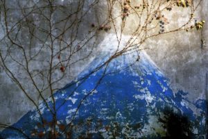
    La dernière éruption du Mont Fuji date de 1707 mais trois départements du Japon (Yamanashi, Shizuoka et Kanagawa) viennent – on ne sait jamais – de mettre en place un plan d’évacuation en cas de coulées de lave ou de nuages de cendre… Tôkyô, mur peint dans le quartier de Nishi-Nippori.

    Le regard d'Eric Rechsteiner 29

    A lire

    Actu

    Centenaire de Shōhei Imamura : trois films à redécouvrir au cinéma en avril

    02/04/2026Par Service communication
    Lire la suite
    Actu

    Exposition Un fantôme qui a du chien

    01/04/2026Par Rédaction de Zoom Japon
    Lire la suite
    Actu

    YABAÏ DŌJŌ : Vivez le Japon au 1er étage de la Tour Eiffel

    26/03/2026Par Service communication
    Lire la suite
    Actu

    Exposition « VOYAGER LE JAPON » de Solveig Sauvage

    25/03/2026Par Service communication
    Lire la suite
    Actu

    Japan Party au Parc Floral de Paris, du 23 au 25 mai 2026

    23/03/2026Par Service communication
    Lire la suite
    Actu

    Ciné Veillée spécial Hayao Miyazaki le 10 avril au cinéma Le Luxy

    19/03/2026Par Service communication
    Lire la suite
    Facebook Instagram
    • Home
    • Qui sommes nous
    • Contact
    • Politique de confidentialité
    • 日本語
    © 2026 Ilyfunet communication

    Type above and press Enter to search. Press Esc to cancel.